
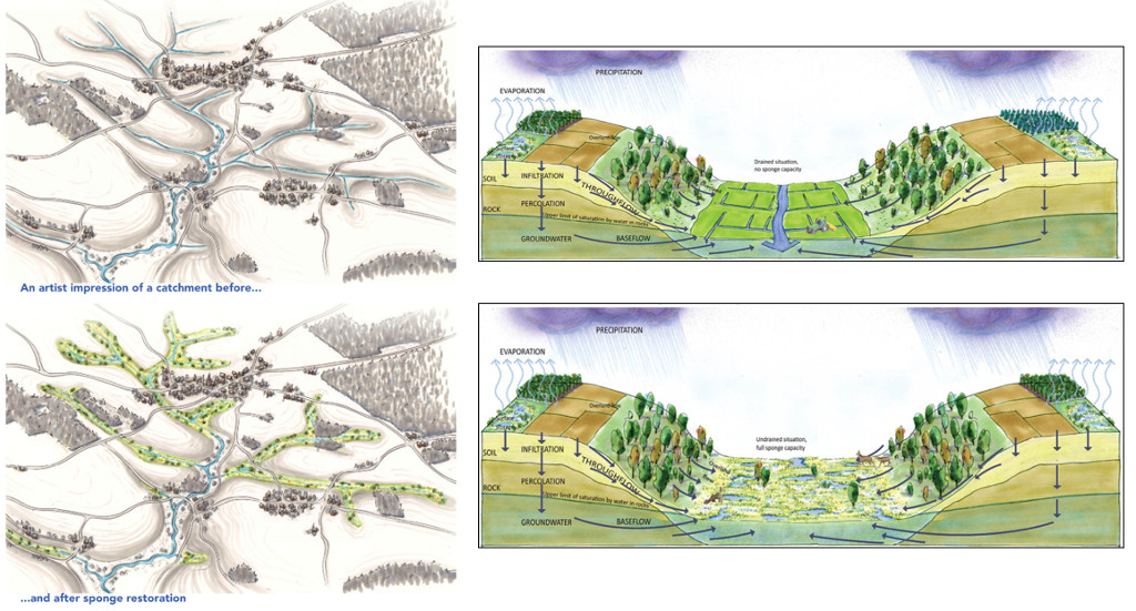
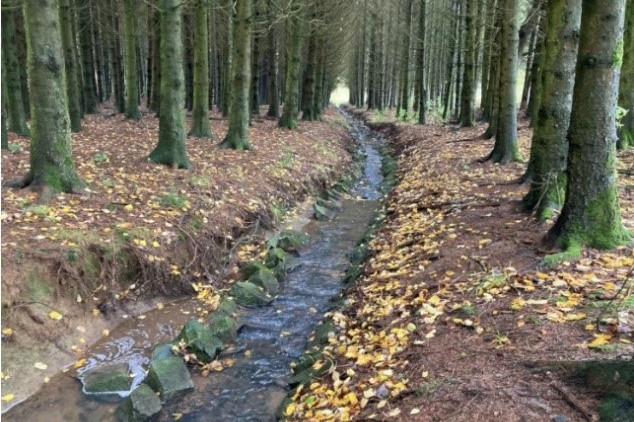
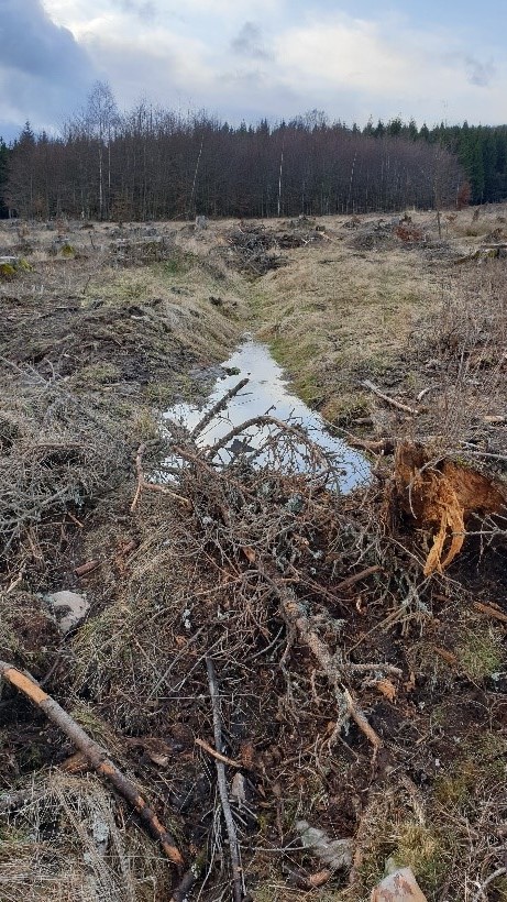
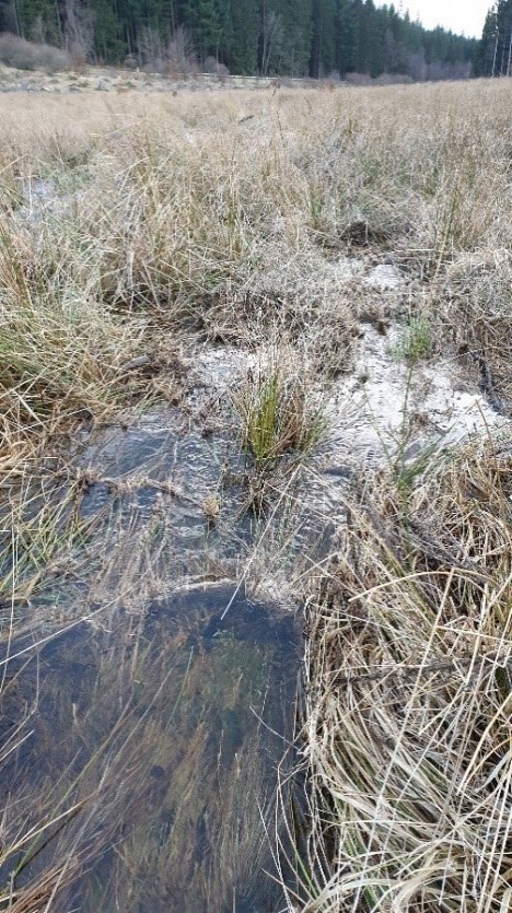
| Application ID | The Netherlands_01 | ||||
| Application Name | Wetland International – European Association | ||||
| Application Location | Country | Germany | Country 2 (in case of transboundary applications) |
||
| NUTS2 code | |||||
| River Basin District Code | River Kyll, Middle Rhine Catchment | ||||
| WFD Water Body Code | |||||
| Description | Kyll river, upstream of Steinebrück, tributary of the Mosel. | ||||
| Application Site Coordinates (in ETRS89 or WGS84 coordinate system) |
Latitude (WGS84): 50.37 | Longitude (WGS84): 6.42 | |||
| Target Sector(s) | Primary: | Nature | |||
| Secondary: | Agriculture | ||||
| Implemented NWRM(s) | Measure #1: | Social Cost – benefit analyses for rewetting upstream catchment areas in the German Middle Mountains and upscaling them to the Rhine Basin. Rewetting by removing humanly enlarged drainage channels and extended river segments in upstream catchment areas to preserve water near the source and lower peak flows downstream. | |||
| Measure #2: | |||||
| Measure #3: | |||||
| Measure #4: | |||||
| Application short description | Restoration of the natural sponge function of upstream micro-catchments has the potential to let the whole catchment downstream benefit. | ||||
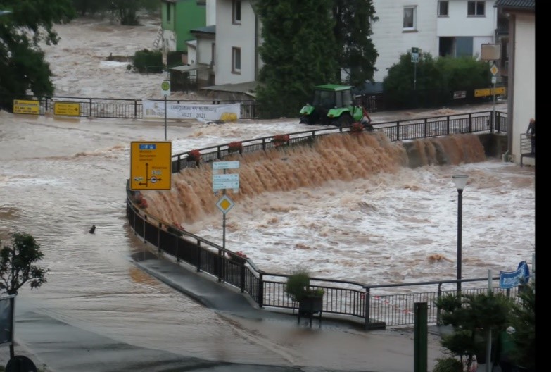
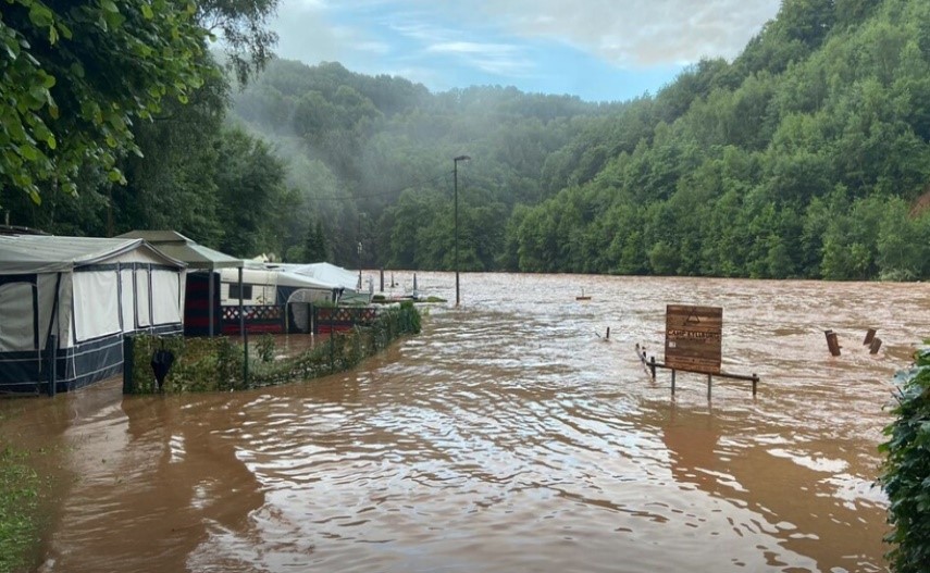
| Brief description of the problem to be tackled | Micro-catchments of big rivers changed dramatically in the last centuries. Marshy, upstream valley parts used to function as “natural sponges”, temporarily storing water from heavy rainfall, before gradually releasing it as small and steady streams. It is important to know that not only rainfall and snow falling in the valley itself was buffered but also precipitation of the much wider, uphill surroundings. Because of this a relatively small patch of wetland on the valley floor had a disproportionally large, regulatory effect. By now, all across Europe these crucially important wetland areas have been drained. The steady flows of water emerging from them changed into strongly pulsating streams, responding almost immediately to changes in rainfall with higher occurrences of both flooding and droughts, on local, regional and (inter)national scale. This already causes problems and without action these will increase because climate change results in more erratic precipitation patterns and thus even more fluctuations in river discharge. | ||||
| What were the primary & secondary targets when designing this application? | Primary target #1: | Self-regulation of water by filtration / storage / accumulation by ecosystems | |||
| Primary target #2: | Flood control and flood risk mitigation | ||||
| Secondary target #1: | Regulation of hydrological cycle and water flow | ||||
| Secondary target #2: | Natural assimilation (purification) of effluents through dilution, dispersion, and physic-chemical processes | ||||
| Remarks: | Carbon storage is another very important target! | ||||
| Which specific types of pressures did you aim at mitigating? | Pressure #1: | Floods Directive identified pressure | |||
| Pressure #2: | WFD identified pressure | ||||
| Pressure #3: | Other EU-Directive's identified pressure | ||||
| Pressure #4: | |||||
| Remarks: | |||||
| Which specific types of adverse impacts did you aim at mitigating? | Impact #1: | Floods Directive identified impact | Flood risk mitigation (and drought prevention) with NBS by delaying and preserving water in upstream catchment areas before in enters the mainstream | ||
| Impact #2: | WFD identified impact | ||||
| Impact #3: | Other EU-Directive's identified impact | ||||
| Impact #4: | |||||
| Remarks: | |||||
| Which EU requirements and EU Directives were aimed at being addressed? | Requirement #1: | Floods Directive-mitigating Flood Risk | Flood risk mitigation (and drought prevention) with NBS by delaying and preserving water in upstream catchment areas before in enters the mainstream | ||
| Requirement #2: | WFD-achievement of good chemical status | Retention of nutrients in upstream catchment areas | |||
| Requirement #3: | Other EU-Directive requirements | Green Deal climate mitigation by sequestration of carbon | |||
| Requirement #4: | |||||
| Remarks: | |||||
| Which national and/or regional policy challenges and/or requirements aimed to be addressed? | Building a physical, social, Institutional and economic landscape in upstream catchment areas where land use is in balance with its water and soil system | ||||
| Dominant Land Use type(s) | Dominant land use | 3.1.2 | |||
| Secondary land use | 2.3.1 | ||||
| Other important land use | 1.1.2 | ||||
| Remarks: Most of the forested areas are drained | |||||
| Climate zone | cool temperate moist | ||||
| Soil type (from the list with the FAO classes) | L5704_B321, L5504_B321 | ||||
| Average Slope | sloping (5-10%) | ||||
| Mean Annual Rainfall | 1200 - 1500 mm | ||||
| Mean Annual Runoff | 450 - 600 mm | ||||
| Average Runoff coefficient (or % imperviousness on site) | > 0.8 | ||||
|
Remarks: Precipitation 1207 Potential evapotranspiration 598 Actual evapotranspiration 549 Streamflow 500 Overland flow 403 Lateral flow 13 Percolation to groundwater 280 |
|||||
| Characterization of water quality status (prior to the implementation of the NWRMs) | Concentrations of 0.01 mg l-1 total P and 3.9 mg l-1 total N were measured at Steinebrück station on January 26, 2009 (Rheinland-Pfalz, 2020). | ||||
| Comment on any specific site characteristic that influences the effectiveness of the applied NWRM(s) in a positive or negative way | Positive way: Removal of drainage in forested areas besides the removal of drainage in pasture areas can influence the effectiveness of the NWRM. Upstream areas are important to retain rainfall and delay it to leave the catchment further downstream | ||||
| Negative way: The effectiveness can be less positive if land owners are not willing or able to cooperate. There are many landowners in the upstream areas. | |||||
| Project scale | Large (e.g. watershed, city, entire water system) | It focusses on small upstream catchment areas, the effect though has influences downstream on the river itself and eventually on the Rhine scale | |||
| Time frame | Date of installation/construction (MM.YYYY) | No pilot is started, research project | |||
| Expected average lifespan (life expectancy) of the application in years | Decades | ||||
| Responsible authority and other stakeholders involved | Name of responsible authority/ stakeholder | Role, responsibilities | |||
| European Union | Green Deal, WFD, Flood directive | ||||
| River commissions | Wetland restoration is an opportunity for better water quality, flood prevention and WFD implementation in the Rhine and the Mosel. | ||||
| Nature organizations and environmental NGO’s | The Sponge Project partners set up studies about wetland restoration. The natural park in the research area would benefit from a lift in biodiversity, water quality and a more regular water flow. (Biodiversity (main), water quality, hydrological cycle) | ||||
| Districts and Municipalities | Related to wetland restoration is the municipal responsibility of administering land-use planning. Furthermore, wetland restoration is of interest to the municipalities, since they are responsible for e.g. attenuating natural disasters like floods, clean drinking water, water abstraction, water legislation, land cultivation and in general for implementing (environmental) laws (Auge, 2020; Haschke, 1998; Vidaurre et al, 2016) (hazard regulation (flood/drought), water quality, hydrological cycle, food and fibre provision) | ||||
| Farmers/landowners | Wetland restoration requires land that is still mostly in the hands of private owners. This is where a competing interest is identified. However, wetland restoration also brings advantages for this stakeholder, through ESs such as tourism, flood prevention. Also financial land compensation can benefit them. (Food and fibre production (main), tourism, flood prevention) | ||||
| The application was initiated and financed by | Initiated by Wetland International Europe, Financed by the JRC | ||||
| What were specific principles that were followed in the design of this application? | Nature-based solution, technically simple with low costs for implementation, restore natural processes in the upstream catchment areas for the beneficial of the upstream residence and downstream residence | ||||
| Area (ha) | Number of hectares treated by the NWRM(s) | 47,6 km2 | |||
| Text to specify | The catchment of Steinebrück is 47.6 km2, the NWRM has a direct effect upstream of Steinebrück. There are significant effects downstream when the NWRM could be upscaled. | ||||
| Design capacity | Design capacity is delaying 20 – 30% of the peak discharge in Steinebrück when 38% of the available sponge sites in the catchment are restored. | ||||
| Reference to existing engineering standards, guidelines and manuals that have been used during the design phase | Reference | URL | |||
| 1 | https://europe.wetlands.org/publications/sponge-restoration/ | ||||
| 2 | https://europe.wetlands.org/publications/wetland-restoration-impact-on-streamflow-rhine-basin/ | ||||
| 3 | |||||
| 4 | |||||
| 5 | |||||
| Main factors and/or constraints that influenced the selection and design of the NWRM(s) in this application? | Size of the catchment, location of the catchment, land use | ||||
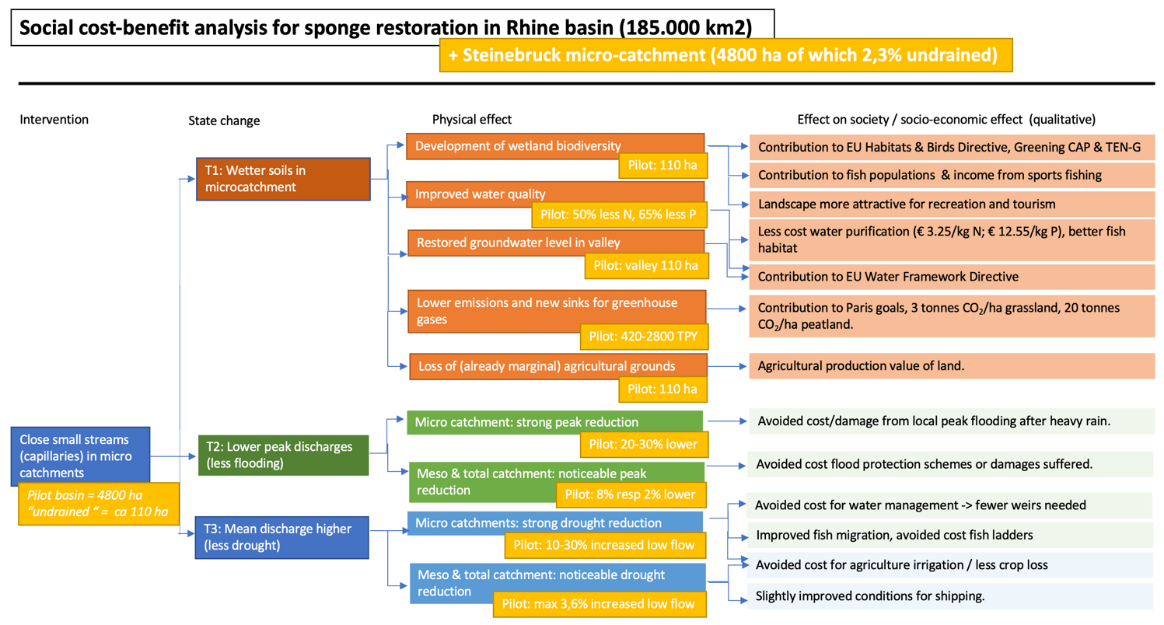
| Impact category | Impact description The response of streamflow to extreme rainfall events was attenuated, as peaks were lower but broader after wetland restoration. In this way, the maximum annual peak discharge decreased by an average of 12 – 24% in the three micro-catchments of the Rohrbach and Lewertbach streams. At the larger scale of the Kylldal catchment, with its outlet at Steinebrück, however, maximum annual winter peak flows were 10% lower after wetland restoration at 38% of the available sites. The delay in flow after extreme precipitation events also causes a higher baseflow recession after wet periods. The change to lower peak discharges and higher water availability in drier periods can be viewed as a positive impact on the hydrological regime of these areas. Nutrient exports from the Kylldal catchment were low for the reference scenario, which can be due to the limited area of pasture in the catchment, the use of filter strips to reduce stream nutrient loading and the relatively low amounts of manure applied on pasture. Wetland restoration did have a positive impact on the nutrient exports from the project areas and the Kylldal catchment as a whole. Nitrogen and phosphorous loads and concentrations were reduced by up to 67% in the project areas. The effect at catchment scale was somewhat lower, but still substantial, with simulated reductions in the order of 20%. Based on this study, wetland restoration can be viewed as a viable ecosystem-based solution to improve the hydrological services of catchments. The largest gains for both streamflow and nutrient exports can be expected in agricultural areas that now experience considerable fast runoff into the drainage and main channels. |
Impact quantification | |||
| Parameter value; units and/or |
% change in parameter value as compared to the state prior to the implementation of the NWRM(s) | ||||
| Runoff attenuation / control | |||||
| Peak flow rate reduction | 10 – 30% reduction with 38% of the area with sponge restoration | ||||
| Impact on groundwater | |||||
| Impact on soil moisture and soil storage capacity | |||||
| Restoring hydraulic connection | |||||
| Water quality Improvements | 20% reduction of N peak discharge | ||||
| WFD Ecological Status and objectives | |||||
| Reducing flood risks (Floods Directive) | 10 – 30% reduction with 38% of the area with sponge restoration | ||||
| Mitigation of other biophysical impacts in relation to other EU Directives (e.g. Habitats, UWWT, etc.) | EU Habitats Directive priority habitat. Wetland restoration also contributes to the goals of the EU Birds Directive (such as Breeding and feeding grounds for songbirds, waders and waterfowl), the goals of greening the Common Agricultural Policy and the Trans-European Network for Green Infrastructure TEN-G. | ||||
| Soil Quality Improvements | |||||
| Other | |||||
| What are the benefits and co-benefits of NWRMs in this application? |
|
||||
| Financial costs (estimation) Value in € (Total + possible breakdown) |
Total | Value in € | |||
| Capital: | 546.000,00 € | Per hectare / per decade | |||
| Land acquisition and value: | 180.000,00 € | Per hectare / per decade | |||
| Operational: | 25.000,00 € | Per hectare / per decade | |||
| Maintenance: | 91.000,00 € | Per hectare / per decade | |||
| Other: monitoring | 125.000,00 € | Per hectare / per decade | |||
| Were financial compensations required? What amount? | Was financial compensation required: - | ||||
| Total amount of money paid (in €): - | |||||
| Compensation schema: - | |||||
| Comments / Remarks: Research project, not yet implemented | |||||
| Economic costs | Actual income loss: - | ||||
| Additional costs: - | |||||
| Other opportunity costs: - | |||||
| Comments / Remarks: Research project, not yet implemented | |||||
| Which link can be made to the ecosystem services approach? |
|
||||
| Monitoring requirements | Research project, not yet implemented | ||||
| Maintenance requirements | Research project, not yet implemented | ||||
| What are the administrative costs? | Research project, not yet implemented | ||||
| Which assessment methods and practices are used for assessing the biophysical impacts? | Pre vs post, business as usual vs NWRM | ||||
| Which methods are used to assess costs, benefits and cost-effectiveness of measures? | Teeb methodology | ||||
| How cost-effective are NWRM's compared to "traditional / structural" measures? | enefit / cost ratio is estimated on 2.4. Every 1 euro spend provides 2.4 Euro’s benefits | ||||
| How do (if applicable) specific basin characteristics influence the effectiveness of measures? | They influence them enormously. NWRM in this case can be implemented in upstream river catchments in middle mountain areas in the whole of Europe with low sloping areas https://media.stroming.nl/sponges/ | ||||
| What is the standard time delay for measuring the effects of the measures? | Hydrological effect are immediate, ecological effects takes 3 – 5 years | ||||
| What were the main implementation barriers? |
|
||||
| What were the main enabling and success factors? | The benefits from investing in upstream catchment areas for reducing peak flows, increasing low flows and carbon sequestration. | ||||
| Financing | Research project, not yet implemented | ||||
| Flexibility & Adaptability | Research project, not yet implemented | ||||
| Transferability | Research project, not yet implemented | ||||
| Key lessons | Natural sponges in lower mountain ranges of European river basins are with favourable characteristics are a nature-based solution with the potential to be effective for attenuating floods and droughts and meeting several EU policy objectives related to climate change, water and nature. | ||||
| Source Type | |||||
| Source Author(s) | |||||
| Source Title | |||||
| Year of publication | |||||
| Editor/Publisher | |||||
| Source Weblink | |||||
| Key People | Name / affiliation | Contact details | |||
Kyll river case study - Factsheet
English
Kyll river case study
English
